|
Makin' Groceries in New Orleans |
|
|
|
The Public Markets
|
||||||||||||||||||||||||||||||||||||||||||||||||||||||||||||||||||||
|
|
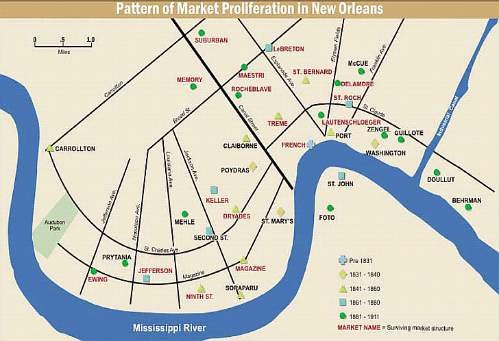
In 1911 the city of New Orleans controlled and/or operated 34 public markets - more than
any other city in the United States. Beginning in the 1700s and ranging through the 1940s, public markets in New Orleans
included: Poydras
Market, on Dryades, between Baronne and Rampart Dryades Market, on Dryades street, between Thalia and Terpsichore streets Claiborne
Market, on Claiborne, between Common and Gasqhet streets The Meat Market, situated on the Levee, between St. Ann and
Dumaine streets The Vegetable Market, comprising the square bounded by St . Philip, Ursulines, Peter and Decatur streets The
Fruit Market, comprising the square between St. Philip, Decatur and Peter streets The Tre'me' Market, on Orleans street,
between Marais, Villere and Robertson streets The Port Market, on Levee, corner of Elysian Fields, large The Washington
Market, corner Louisa and Moreau streets The St. Bernard Market, corner Claiborne and St . Bernard streets A piece
of ground, bounded by Mexico and Dublin streets, and East and West Elysian Fields, left by A. Milne for the erection of a
market Soraparu Market, Soroparu, between Levee and Rousseau Magazine Market, bounded by Magazine, St. Mary and
Camp streets Ninth Street Market, bounded by Magazine, Camp, Constance and Ninth streets Ninth Ward Markets included Doullut Behrman, Washington, Guillotte
and Zengel. 1880 map of markets
- http://upload.wikimedia.org/wikipedia/commons/1/1d/New_Orleans_Markets_map_1880.jpg
Source: THE PUBLIC MARKET SYSTEM
OF NEW ORLEANS: FOOD DESERTS, FOOD SECURITY, AND FOOD POLITICS
|
|
||||||||||||||||||||||||||||||||||||||||||||||||||||||||||||||||||
|
Unless otherwise noted, the photographs on this website are from the Louisiana Digital Library.
|
||||||||||||||||||||||||||||||||||||||||||||||||||||||||||||||||||||